
Table of Contents
Key Takeaways on Using AI in Mosquito Surveillance
1. Introduction: From Traditional Surveillance To Digital Intelligence
Mosquito-borne diseases still shape global public health in ways that are easy to underestimate until an outbreak hits.
At the center of every serious vector-control program is one unglamorous but critical activity: mosquito surveillance. Mosquito surveillance involves more than counting mosquitoes. It aims to characterize vector species, abundance, distribution, habitat, pathogen infection, and changes over time in order to support risk assessment and public-health action. Historically, much of this work has depended on field technicians, trained entomologists, laboratory identification, and manual data recording. These remain essential components of surveillance today.
What Traditional Mosquito Surveillance Actually Does?
Traditional surveillance is the backbone. It is the field work, the traps, the lab IDs, the weekly counts.
Its core jobs are to:
- Place traps: collection via traps before the start of mosquito season
- Identify which mosquito species are present
- Measure how many are around (abundance)
- Map where they occur (distribution)
- Characterize breeding sites and habitats
- Test for pathogen infection status (e.g., West Nile virus in Culex, dengue in Aedes)
- Track changes over time — seasonal peaks, year-to-year trends, responses to interventions
This information provides an important evidence base for decisions about surveillance intensity, vector-control activities, and evaluation of interventions. Without reliable surveillance data, these decisions are more difficult to target, evaluate, and adapt. (CDC, 2023; WHO, 2021).
For decades, many surveillance programs have faced limitations in data volume, geographic coverage, consistency, timeliness, and integration.
Many programs struggled to:
- Deploy enough traps
- Cover enough geography
- Process samples fast enough
- Maintain consistent methods over time
So the dominant question was:
“How do we collect more mosquito data?”
Modern surveillance increasingly generates large, diverse datasets:
- Entomological data from multiple trap types and methods
- Laboratory results (species IDs, infection rates)
- Environmental data (temperature, rainfall, humidity, land use)
- Epidemiological data (human case counts, serosurveys)
- Geospatial data (GPS coordinates, satellite imagery, GIS layers)
So, lately the new constraint is not only collection, but integration and interpretation.
The central question is becoming:
“How can we integrate and interpret these data more efficiently to support public-health decisions?”
This is where digital technologies and artificial intelligence (AI) enter the picture — not as replacements for field work, but as tools to make existing surveillance data more informative and actionable. That is the gap digital surveillance and AI are trying to fill — not by replacing the trap, the microscope, or the entomologist, but by helping teams process what those tools already produce.
This article looks at how AI-assisted digital mosquito surveillance is actually being used across different regions, what it can genuinely do, and — just as important — what it still cannot.
2. Current Challenges In Mosquito Surveillance Programs
In practice, running a surveillance system that consistently produces reliable, timely, and actionable information is much harder.
Even well-resourced vector-control programs run into the same handful of problems, face a mix of operational, technical, and analytical constraints. Understanding these constraints is essential before introducing AI or digital tools.
- Field work is labor-intensive and geographically limited
- Species identification depends on scarce expertise
- Data are fragmented across systems
- Manual processing slows interpretation
- Spatial and seasonal patterns are hard to see from isolated observations
None of these constraints means traditional surveillance is outdated.
Traditional surveillance is not obsolete — it needs extension
On the contrary:
- Field-based surveillance and expert-validated laboratory data remain foundational for understanding vector populations and validating digital surveillance outputs.
- Human expertise in entomology and epidemiology is irreplaceable for interpretation and decision-making
- Many successful control programs are built on decades of consistent, methodical surveillance
The challenge is that the scale and complexity of current and emerging threats are growing:
- Environmental and climatic changes can alter the geographic suitability and seasonal dynamics of vectors such as Aedes aegypti and Aedes albopictus. (Ryan et al., 2019)
- Global travel and trade accelerate the spread of both vectors and pathogens (WHO, 2023)
- Public expectations for rapid, data-driven responses are higher than ever
Digital technologies and AI should be seen as ways to extend the reach and analytical capacity of existing surveillance, not to discard it.
AI assisted surveillance can help:
- Process larger volumes of data more quickly
- Integrate fragmented datasets into a more coherent picture
- Highlight patterns that warrant closer human review
- Support more timely and targeted public-health actions
But they depend on a foundation of robust, standardized, field-based surveillance. Without that, even the most advanced algorithms will struggle to add real value.
Table 1. Common challenges in mosquito surveillance and how digital/AI tools can help
| Challenge | How it affects surveillance | How digital/AI tools can help (with caveats) |
|---|---|---|
| Labor-intensive field work | Limited geographic coverage and sampling frequency | Mobile data collection apps; optimized trap placement using spatial models (still requires field staff) |
| Dependence on taxonomic expertise | Bottlenecks in species ID; risk of misidentification | AI image recognition as assistive tool; still needs expert validation and molecular confirmation |
| Fragmented data systems | Delays in integrating entomological, epidemiological, and environmental data | Integrated databases and APIs; requires agreed standards and governance |
| Manual data processing | Slow turnaround from collection to decision | Automated data pipelines and dashboards; must be paired with quality control |
| Difficulty seeing spatial/seasonal patterns | Hard to distinguish real trends from noise | Spatiotemporal models and risk maps; need sufficient, consistent data to be reliable |
| Data quality issues (gaps, bias, inconsistency) | Models learn wrong patterns; misleading outputs | Data-quality dashboards, validation routines; cannot replace good field methods |
3. Use of AI in Mosquito Surveillance System
Emerging digital mosquito-surveillance systems can combine smart traps, imaging devices, IoT connectivity, computer-vision algorithms, and environmental data. However, the specific configuration varies substantially across research prototypes, pilot projects, and operational settings.
AI Mosquito Surveillance: How It Works?
The system operates through three core layers: capture, recognition, and intelligence—supported by several enabling technologies that make it reliable and scalable in the field.
- Smart Traps (Capture Layer): Devices use a combination of attractants—including LED lights tuned to specific wavelengths, CO₂ plumes that mimic human breath, chemical lures (such as lactic acid or octenol), and controlled air flow—to draw mosquitoes onto sticky pads or into capture units. Depending on the design, some traps incorporate host-related cues such as heat, moisture, CO₂, or chemical attractants to influence mosquito capture.
Each trap is geo-tagged with GPS, so every capture is tied to precise coordinates for spatial mapping, and solar panels with battery backups keep devices running in remote areas for extended periods.
- Image Recognition (Recognition Layer): Built-in microscopes or high-resolution cameras photograph the captured insects and feed the images into artificial intelligence (AI) models—such as YOLO (You Only Look Once) or other convolutional neural networks (CNNs)—to classify mosquito taxa and, in some systems, estimate sex or other morphological characteristics.
Reported performance can be high under specific study conditions, but accuracy varies with species, geographic setting, image quality, training data, and validation design. On-device edge computing allows traps to filter and classify images locally, reducing bandwidth needs, while species-specific AI training on region-specific image libraries ensures accuracy across different geographies.
- Data Dashboards (Intelligence Layer): Units connect to central servers via IoT (Internet of Things), aggregating data on population density, species distribution, and environmental variables such as temperature, humidity, and rainfall. These inputs can be incorporated into predictive models that estimate vector abundance, distribution, or disease-related risk, depending on the available data and modelling framework.
Where validated thresholds and appropriate operational protocols exist, automated systems may generate alerts when predefined surveillance indicators reach specified levels.
Supporting Infrastructure Used in AI Mosquito Surveillance
- Edge Computing: On-device processing allows traps to filter and classify images locally, reducing bandwidth needs and enabling operation in remote areas with limited connectivity.
- GPS & Geolocation: Each trap is geo-tagged, so every capture is tied to precise coordinates—essential for spatial mapping and targeted interventions.
- Power & Connectivity Management: Solar panels, battery backups, and low-power communication protocols (like LoRaWAN or NB-IoT) keep devices running in the field for extended periods.
- Species-Specific AI Training: Models must be trained on region-specific image libraries, since mosquito morphology varies by geography and species prevalence.
- Automated Alerts & Early Warning: When trap counts or infection-linked species exceed thresholds, the system sends real-time alerts to public health officials, enabling rapid response.
- Data Integration & Interoperability: The system links with GIS platforms, climate databases, and health records to correlate mosquito activity with disease outbreaks (e.g., dengue, malaria, Zika).
- Quality Control & Calibration: Regular calibration of sensors, image validation by experts, and model retraining ensure long-term accuracy and reduce false positives.
- Privacy & Data Security: Encrypted transmission and compliance with data protection regulations protect sensitive location and health data.
- Scalability & Maintenance: Modular trap designs and remote diagnostics allow the network to expand across regions without proportional increases in manual upkeep.
4. AI-Assisted Mosquito Identification
One of the most visible and intuitive applications of AI in mosquito surveillance is image-based species identification.
Instead of relying solely on human experts to examine morphological features under a microscope, AI-based computer-vision models can be trained to recognize species from photographs that potentially speed-up identification, reduce workload, and enable new types of large-scale data collection.
How image-based AI mosquito identification works?
At a high level, AI-assisted identification follows a familiar machine-learning pipeline:
- Data collection: Thousands to millions of mosquito images are gathered, ideally covering multiple species, sexes, life stages, angles, and geographic variants.
- Annotation: Experts label each image with the correct species (and sometimes additional metadata like sex, region, or quality flags).
- Model training: Deep-learning architectures — often convolutional neural networks (CNNs) — learn to associate visual patterns with species labels.
- Validation: Models are tested on held-out datasets to measure accuracy, precision, recall, and error types.
- Deployment: Trained models are integrated into apps, lab workflows, or field tools to classify new images in real time or batch mode.
Some systems go further, attempting to:
- Distinguish males from females
- Identify specific vector complexes (e.g., Anopheles gambiae s.l. members)
- Detect key morphological features (wing patterns, leg banding, proboscis shape) automatically
- Beyond whole-body images, AI-based geometric morphometrics of wings and deep learning on wing venation patterns have shown high accuracy in distinguishing closely related species, complementing traditional morphological keys (Mondal et al., 2025; Carvajal et al., 2016).
Potential applications of AI in mosquito surveillance programs
AI-based mosquito identification can fit into several parts of a surveillance workflow:
- Lab triage: Automatically pre-sort bulk trap images or microscope photos, flagging likely target species for expert review.
- Field screening: Enable field staff to photograph specimens and get an immediate preliminary ID, guiding decisions on which samples to prioritize for pathogen testing.
- Citizen science and community monitoring: Support apps where residents upload mosquito photos from their neighborhoods, expanding spatial coverage beyond official trap networks.
- Training and quality control: Provide feedback to trainees learning morphological identification, highlighting which features the model used for its prediction.
In all these scenarios, the value is not just speed, but scalability. Programs can potentially handle more samples, cover more areas, and engage more people without proportionally increasing expert workload.
Current real-world applications of AI in mosquito surveillance
AI is increasingly moving from research prototypes toward pilot and operational applications in mosquito surveillance, although the level of implementation and validation varies considerably across settings. The examples below illustrate how AI is currently being used to strengthen mosquito identification, habitat mapping, and risk forecasting in practice.
1. VectorCam (Uganda / USA)
A handheld, smartphone-based device with a 15× macro lens and on-device computer vision that identifies mosquito genus, species group, sex, and abdominal status from a single image. Designed for community health workers in rural Uganda, it uploads results to a central dashboard and has shown positive usability in field testing (Dasari et al., 2024).
2. Smart Mosquito Surveillance System (SMoSS)
The Andhra Pradesh pilot program in India combines AI-enabled sensing, IoT technologies, and other digital tools to support mosquito monitoring and targeted control. Its longer-term effectiveness and scalability require continued evaluation (Elets eHealth, 2025).
3. Mosquito Alert platform (Europe and global)
Mosquito Alert is a citizen-science and public-health platform that combines user-submitted observations and images with automated classification and expert validation to support mosquito surveillance and invasive-species monitoring.
4. Smart mosquito traps with embedded AI (e.g., IoT traps in Asia and Americas)
Research and pilot systems have demonstrated the feasibility of camera-equipped traps combined with machine-learning algorithms for automated mosquito counting and classification, with the potential to reduce manual processing. (Liu et al., 2023; Mondal et al., 2025).
5. The Dengue Early Warning System (DEWS)
A separate 2026 development by Kerala’s Institute of Advanced Virology has reported a Dengue Early Warning System, a machine learning system that combines epidemiological and meteorological data to generate district-level forecasts. The reported system generates district-level risk forecasts intended to support earlier preparedness and vector-control planning. Continued validation will be important before broader conclusions about operational effectiveness are drawn (NDTV Health, 2026).
6. VectorBrain deep-learning model (Americas)
A lightweight deep-learning model developed to identify key vector species such as Aedes aegypti, Aedes albopictus, and Culex quinquefasciatus from images. It has been developed to classify important mosquito vector species from images, illustrating the potential for rapid identification with relatively modest hardware requirements (Araujo et al., 2025).
7. AI-based wing geometric morphometrics (multiple regions)
Systems that use AI to analyze wing venation patterns and geometric morphometric features for species discrimination, especially within cryptic complexes. These tools complement traditional morphology and improve accuracy where whole-body images are ambiguous (Mondal et al., 2025; Carvajal et al., 2016).
8. Automated larval habitat detection using drones and satellite imagery (pilot projects)
AI models applied to drone and satellite imagery detect potential larval habitats (e.g., standing water, irrigation channels, abandoned containers) and map them at neighborhood scale. These spatial tools guide targeted field inspections and larval source reduction in urban and peri-urban areas (Stanton et al., 2021).
9. Mobile apps with AI species ID for citizens and field staff (global)
Smartphone apps (e.g., Mosquito Alert, AI Mosquito Identifier, and research prototypes) allow users to photograph mosquitoes and receive automated or near-real-time species predictions, depending on the application and available connectivity. These tools expand spatial coverage beyond official traps and support community-based surveillance and education.
10. AI-enhanced West Nile virus risk forecasting (USA, Europe)
Models that combine temperature, rainfall, historical mosquito data, and infection rates to forecast West Nile virus risk at county or district level. Outputs inform timing of adulticiding, public advisories, and clinician alerts during transmission season (CDC, 2024; ECDC-supported projects).
11. Deep-learning classification for major vector species (Asia, Africa, Americas)
Convolutional neural networks trained on large image datasets to classify major vectors such as Anopheles gambiae s.l., Aedes aegypti, and Culex spp. These models are being piloted in labs and field stations to speed up identification and reduce reliance on scarce taxonomic experts (Lakyiere et al., 2025; Zhang et al., 2021).
None of these tools and applications replaces field surveillance and verification. Their real value is in helping programs decide where to verify first — turning scattered trap counts and sightings into a clearer, near–real-time picture of where risk is rising.
AI Assisted Mosquito Surveillance: Important limitations and risks
Despite promising results in research settings, several limitations must be acknowledged before widespread operational use.
- Closely related species can be hard to distinguish
- Image quality strongly affects performance
- Training datasets may not represent all regions or populations
- Field validation remains necessary
Reported Accuracy of AI-Based Mosquito Identification
Selected figures explicitly reported in the peer-reviewed studies discussed in Section 3 — not all studies quantified accuracy, so this shows only the cases with a stated number.
Note: the BNITM model outperformed the 81.5% expert baseline in that study, but an exact model accuracy figure was not specified in the source reporting, so it is omitted here rather than estimated. Bars are not directly comparable across studies — species counts, imaging conditions, and open- vs. closed-set tasks differ.
A 2025 systematic review of 52 machine-learning-based mosquito identification studies highlighted recurring constraints that limit real-world applicability (Lakyiere et al., 2025). Key issues included limited dataset diversity, with many models trained on small, geographically narrow image sets; inconsistent preprocessing practices across devices and studies; and high computational requirements that hinder deployment on low-end hardware.
The review also noted that morphological similarities between certain species, especially within complexes, continue to challenge model robustness. These findings underscore the need for larger, more diverse annotated datasets, standardized imaging protocols, and investment in low-resource model deployment strategies, including African-led research initiatives to ensure context-relevant surveillance tools (Lakyiere et al., 2025).
Table 2. AI applications in mosquito surveillance: Uses and Limitations
| Application | What AI can do | Key limitations |
|---|---|---|
| Image-based species ID | Rapid preliminary classification of mosquitoes from photos | Struggles with closely related species, poor image quality, and underrepresented regions |
| Environmental data integration | Combine temperature, rainfall, land use, etc. with vector data to find patterns | Depends on quality and resolution of environmental layers; correlations not equal to causation |
| Spatial risk mapping | Generate continuous maps of vector presence/abundance from point data | Uncertain in data-sparse areas; must be validated with field work |
| Predictive forecasting | Estimate future vector abundance or infection risk weeks ahead | Sensitive to data quality, model assumptions, and unexpected events |
| Decision support | Prioritize areas for surveillance or intervention | Cannot replace human judgment on feasibility, equity, and local context |
Note: Reported accuracy values are not directly comparable across studies because datasets, mosquito species, imaging conditions (e.g., device type, lighting, magnification), and validation designs differ substantially between studies.
AI in Mosquito Identification: Where this fits in the bigger picture
Image-based identification is important, but it is only one piece of digital surveillance. Even if every specimen were identified instantly and perfectly, programs would still face challenges of:
- Integrating those IDs with environmental and epidemiological data
- Interpreting spatial and temporal patterns
- Translating insights into targeted interventions
5. Integrating Environmental Data With Entomological Observations
Mosquito populations are strongly environment-driven. Their presence, abundance, and behavior are tightly linked to the environment around them.
Key factors include:
- Temperature: Affects development rates of larvae, adult survival, and the extrinsic incubation period of pathogens (the time it takes for a virus or parasite to become transmissible inside the mosquito). Warmer temperatures generally speed up development up to a species-specific optimum, beyond which survival drops (Mordecai et al., 2019).
- Rainfall and water availability: Create or eliminate breeding sites. Heavy rains can fill containers, flood depressions, and expand wetlands, while droughts can concentrate mosquitoes around remaining water sources (Ryan et al., 2019).
- Humidity: Influences adult mosquito survival and activity; very dry conditions can reduce lifespan and biting activity.
- Vegetation and land cover: Provide resting sites, shade, and microclimates; certain land-use types (urban, agricultural, forested) favor different mosquito communities.
- Urbanization: Alters heat profiles (urban heat islands), drainage patterns, and human density, all of which affect vector dynamics and exposure risk.
The data integration challenge
In principle, linking mosquito data with environmental data is straightforward: for each trap location and date, pull in corresponding weather, land-use, and hydrology data.
But in practice, several obstacles arise:
- Different formats and resolutions: Entomological data may be point-based (trap coordinates), while environmental data come as gridded rasters (e.g., satellite imagery) or station-based measurements (weather stations).
- Temporal mismatches: Mosquito counts might be weekly, while environmental data are daily, monthly, or seasonal composites.
- Missing or inconsistent metadata: Trap locations without precise coordinates, dates in inconsistent formats, or unclear sampling effort complicate linkage.
- Multiple data sources: Weather data may come from national meteorological services, land-use from satellite products, water data from hydrological models — each with its own access rules and update cycles.
As a result, many surveillance programs analyze entomological and environmental data separately, or use simple correlations rather than integrated models.
How AI can integrate multiple environmental variables
Rather than analyzing each environmental factor in isolation, AI models can consider them jointly, capturing interactions that might be missed by simpler approaches.
Common approaches include:
- Supervised learning models (e.g., random forests, gradient boosting, neural networks) that predict mosquito abundance or presence/absence using multiple environmental predictors.
- Spatiotemporal models that incorporate both location and time, learning how environmental conditions at different lags (e.g., rainfall two weeks ago) influence current vector levels.
- Feature-learning methods that automatically identify which combinations of variables are most predictive in different regions or seasons.
For example, a model might learn patterns such as:
- In some urban settings, higher temperatures together with moderate rainfall and certain land-cover types are associated with increased Aedes aegypti abundance.
- In some agricultural areas, Culex populations appear more strongly linked to irrigation patterns and night-time temperatures than to total rainfall.
These are illustrative examples; the specific relationships learned by any model will depend on the local vector species, environment, and the surveillance data used for training.
Such insights can help refine:
- Where to place or intensify traps
- When to anticipate seasonal peaks
- Which environmental thresholds might trigger alerts
Global and regional studies have shown that models integrating multiple environmental layers can outperform single-variable approaches in predicting vector distribution and seasonal dynamics (Kraemer et al., 2019; Ryan et al., 2019).
Types of environmental data commonly used
While specific datasets vary by region, common categories include:
(i) Meteorological data:
- Temperature (mean, min, max, diurnal range)
- Rainfall (total, intensity, frequency)
- Humidity, wind, solar radiation
- Sources: national weather services, NOAA, ECMWF, CHIRPS, etc.
(ii) Remote-sensing and land-cover data:
- Vegetation indices (e.g., NDVI)
- Land-use/land-cover maps (urban, forest, agriculture, water bodies)
- Surface temperature and moisture
- Sources: Landsat, Sentinel, MODIS, Copernicus programs
(iii) Hydrological and water-related data:
- Surface water extent
- Soil moisture
- Proximity to rivers, lakes, wetlands, irrigation canals
- Sources: satellite-derived water maps, hydrological models, local water authorities
(iv) Urban and socioeconomic layers (where relevant):
- Population density
- Building density and type
- Infrastructure (drainage, waste management)
- Sources: census data, OpenStreetMap, global urban datasets
AI systems do not need to understand these variables in a human sense. They can learn statistical associations between patterns in these layers and observed mosquito data.
However, human expertise remains critical to:
- Select biologically plausible predictors
- Avoid spurious correlations (e.g., variables that correlate by chance in a specific dataset)
- Interpret model outputs in light of known vector ecology
From correlation to actionable insight
The goal of integrating environmental data is not just to build accurate models, but to generate actionable intelligence.
Well-designed integration can help answer questions like:
- Which environmental conditions typically precede a surge in vector abundance?
- Are there thresholds (e.g., cumulative rainfall over 10 days, average night temperature) that consistently signal elevated risk?
- How might changes in land use or climate shift vector distributions over time?
- Which areas are likely to become newly suitable for key vectors under future scenarios?
These insights can inform:
- Seasonal preparedness: Pre-positioning resources ahead of predicted peaks.
- Targeted surveillance: Focusing traps in areas where environmental conditions suggest emerging risk.
- Long-term planning: Anticipating how urban development or climate change might alter vector landscapes.
Importantly, these models should be treated as decision-support tools, not oracles. Their predictions need to be validated against field data and interpreted by people who understand local conditions.
Figure 2. AI models integrate multiple environmental variables to estimate vector distribution and risk. Outputs must be interpreted with local ecological knowledge.
6. GIS, Remote Sensing, and Spatial Intelligence in Vector Mapping
Maps have always been central to mosquito surveillance.
Pin maps on lab walls, hand-drawn outbreak sketches, printed heat maps in meeting rooms — these are all early forms of spatial intelligence. They help answer basic but critical questions: Where are mosquitoes? Where are cases? Where should we act next?
What has changed is the volume, resolution, and complexity of spatial data now available, and the ability of AI-enhanced GIS (Geographic Information Systems) and remote sensing to turn fragmented observations into coherent risk pictures.
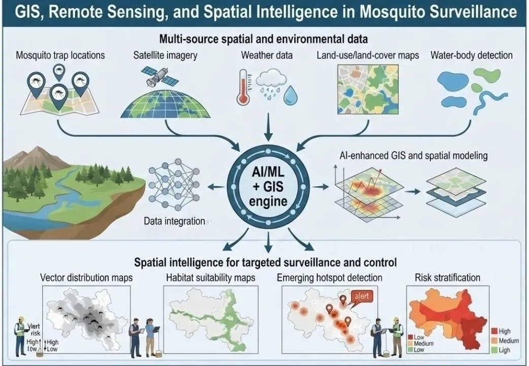
Table 3. Common remote sensing and GIS data layers used in contemporary vector surveillance.
| Data source / platform | Variable captured | Typical surveillance application |
| Landsat | Land use, land cover, surface temperature | Habitat-suitability mapping (Abbasi, 2025) |
| MODIS | Land-surface temperature, vegetation indices | Climate-driven vector-density modelling |
| Sentinel-2 | High-resolution multispectral imagery | Urban habitat and breeding-site mapping |
| NDVI (derived index) | Vegetation density and health | Correlation with breeding/resting habitat |
| Drone / UAV imagery | High-resolution habitat imagery | Targeted larval-habitat detection (Gonzalez et al., 2023) |
| ArcGIS / QGIS | Spatial analysis and mapping platform | Risk mapping and hotspot detection (Nayak et al., 2025) |
None of this replaces field verification; what it does is help programs decide where field verification should happen first, turning fragmented point observations into something closer to a continuous risk surface.
Possible applications for AI-integrated GIS and remote-sensing technologies
(i) AI based spatial modeling for continuous risk surfaces
Between traps, there are gaps. Outside sampled neighborhoods, there are blind spots. Over time, the pattern of traps may change, making comparisons difficult. AI and spatial modeling can help transform these discrete points into continuous risk surfaces — maps that estimate vector presence, abundance, or infection risk across an entire area, not just at sampled locations.
Common techniques for GIS mosquito mapping include:
- Geostatistical interpolation (e.g., kriging) that leverages spatial autocorrelation to estimate values between known points.
- Machine-learning models that relate trap data to environmental covariates (temperature, land cover, water indices) and predict vector metrics across unsampled areas.
- Spatiotemporal models that account for both space and time, capturing how risk surfaces evolve over weeks or seasons.
Global mapping efforts for Aedes aegypti and Aedes albopictus, for example, combine occurrence records with environmental layers in statistical and machine-learning frameworks to produce high-resolution distribution maps (Kraemer et al., 2019; Ryan et al., 2019). Similar approaches are used for Anopheles vectors of malaria and Culex vectors of West Nile virus.
For local programs, these methods can:
- Highlight likely hotspots between trap sites
- Identify under-sampled areas that may warrant new traps
- Support scenario planning (e.g., how might risk shift if land use changes?)
(ii) Measuring Earth surface properties with Remote sensing
Remote sensing — the use of satellite or aerial imagery to measure Earth surface properties — provides a rich set of inputs for spatial vector surveillance.
Key data types include:
- Vegetation indices (e.g., NDVI) that indicate greenness and can proxy for moisture, shade, and potential breeding habitats.
- Land-use/land-cover maps distinguishing urban, agricultural, forested, and water bodies — each associated with different mosquito communities.
- Surface temperature and moisture layers that capture microclimatic conditions influencing mosquito development and survival.
- Water-body detection from radar or optical sensors, identifying ponds, wetlands, flooded areas, and sometimes even smaller features like irrigation channels.
These layers are available at various spatial and temporal resolutions from missions such as Landsat, Sentinel, MODIS, and others (Copernicus program; USGS).
AI methods can:
- Automatically classify land-cover types from imagery
- Detect changes over time (e.g., new construction, deforestation, flooding)
- Extract fine-scale features (e.g., small water bodies) that may be hard to map manually
- Fuse multiple remote-sensing products into composite indicators of habitat suitability
For example, models might learn that combinations of high NDVI, specific land-cover classes, and certain temperature ranges consistently correspond to high Anopheles abundance in a given region.
(iii) Mapping vector distribution and suitable habitats
One of the most direct applications is habitat suitability mapping.
Using known occurrence or abundance data alongside environmental layers, machine learning vector control models can estimate where conditions are favorable for specific mosquito species.
Outputs can include:
- Presence/absence maps: Where is a species likely to occur?
- Abundance indices: Where are populations likely to be higher or lower?
- Seasonal suitability: How does habitat suitability change across months or seasons?
- Future projections: How might suitability shift under climate or land-use scenarios?
These maps can support surveillance prioritization and, where appropriately validated and integrated into program workflows, may inform decisions about targeted interventions:
- Planning trap networks: Ensuring coverage across different habitat types and risk zones.
- Prioritizing interventions: Focusing larval source reduction or adulticiding in areas with high predicted suitability.
- Early detection of range expansion: Identifying areas newly becoming suitable for invasive vectors like Aedes albopictus or Aedes aegypti.
For instance, global and regional models have shown how climate and urbanization are expanding the potential range of Aedes vectors into higher latitudes and altitudes, including parts of Europe and the U.S. (Ryan et al., 2019; CDC, 2024).
(iv) Detecting spatial changes and emerging hotspots
Mosquito landscapes are not static.
Changes can arise from:
- Seasonal weather patterns
- Extreme events (floods, droughts, storms)
- Urban development (new neighborhoods, industrial zones, abandoned lots)
- Changes in water management (irrigation, drainage projects)
AI-enhanced spatial analysis can help detect such changes by:
- Comparing current environmental layers to historical baselines
- Identifying anomalies in vector abundance relative to expected patterns
- Tracking the emergence of new clusters or hotspots over time
For example, a change in surface water combined with other relevant environmental and entomological indicators could identify an area for closer monitoring.
Time-series analysis of satellite data, coupled with trap data, can reveal:
- Where new breeding habitats are forming
- Which neighborhoods are experiencing repeated seasonal spikes
- How vector distributions shift from year to year
This kind of spatial intelligence is especially valuable for early warning and rapid response, potentially providing additional lead time for investigation, preparedness, and response before substantial increases in human cases occur.
(v) Stratifying areas according to surveillance priorities
Not all areas can be monitored or treated with equal intensity. Resources are limited, and risk is uneven.
Spatial intelligence enables risk stratification — dividing a region into zones with different surveillance and intervention priorities.
Common approaches include:
- Risk tiers: Low, medium, high, and very high risk areas based on modeled vector presence, abundance, and environmental suitability.
- Surveillance intensity zones: Areas where traps should be dense and frequent versus areas where sparse monitoring suffices.
- Intervention priority maps: Highlighting where larval control, adulticiding, or public communication should be focused first.
These stratifications can be updated regularly as new data arrive, ensuring that plans reflect current conditions rather than outdated assumptions.
For public-health managers, such maps translate complex datasets into clear operational guidance: “Focus here first; monitor here; maintain baseline surveillance here.”
(vi) Supporting targeted field investigations
Spatial intelligence does not replace field work; it makes field work more efficient.
Instead of sending teams to investigate every complaint or random location, programs can:
- Target areas identified as likely hotspots by models
- Validate predicted high-risk zones with ground-truthing
- Investigate anomalies (e.g., unexpected species in a new area) flagged by spatial analysis
This model-guided fieldwork approach can:
- Reduce time and fuel costs
- Increase the yield of field investigations (more positives per visit)
- Improve understanding of why certain areas are high risk (e.g., specific breeding sites, drainage issues)
Over time, feedback from field teams can also be used to refine models — for example, by correcting misclassified land-cover types or adding new habitat features that the model missed.
From Satellite Data to a Vector Risk Map
How remote sensing layers described in Section 5 typically move through a GIS workflow before reaching a field team.
Satellite Imagery
Landsat, MODIS, Sentinel-2 (Abbasi, 2025; Kalluri et al., 2007)
Environmental Indices
NDVI, land-surface temperature, land cover
GIS Analysis
ArcGIS / QGIS overlay with entomological data (Nayak et al., 2025)
Risk / Hotspot Map
Prioritised zones for field verification
Drone/UAV imagery feeds into the same pipeline at higher resolution and lower revisit cost than satellite tasking (Gonzalez et al., 2023). The map narrows where field teams look first — it does not replace on-the-ground verification.
Limitations and the role of human expertise
Despite its power, spatial intelligence has limits.
Key caveats include:
- Resolution mismatches: Satellite data may be too coarse to detect small but important features (e.g., backyard containers, clogged gutters).
- Cloud cover and data gaps: Optical sensors can be blocked by clouds; some regions have limited high-frequency coverage.
- Model uncertainty: All maps carry uncertainty, especially in data-sparse regions or rapidly changing environments.
- Interpretation risks: A high-suitability map indicates favorable modeled conditions; it does not establish actual vector presence or abundance without field validation.
Human expertise remains essential to:
- Choose appropriate models and parameters
- Interpret maps in light of local knowledge (e.g., known problem areas, recent construction)
- Decide how to act on spatial intelligence given operational constraints GIS and remote sensing, enhanced by AI, should be seen as force multipliers for spatial reasoning, not replacements for on-the-ground verification.
7. Predictive Surveillance and Early Warning Systems
Traditional surveillance provides essential observations of current and recent conditions, but routine monitoring may identify important changes only after they have occurred. By the time a surge in vector abundance or a cluster of positive pools is detected, conditions may already be favorable for transmission — or human cases may already be rising.
Predictive surveillance aims to shift the question from:
“Where are mosquitoes present now?”
to:
“Where and when might vector risk change?”
What predictive surveillance tries to forecast
Predictive models in vector surveillance typically aim to estimate one or more of the following, over future time windows (e.g., 1–4 weeks ahead):
- Vector abundance: Expected mosquito counts or density indices.
- Presence/absence: Likelihood that a species will be detected in a given area.
- Infection risk: Probability of detecting pathogen-positive pools (e.g., West Nile virus in Culex).
- Outbreak potential: Combined risk based on vectors, environment, and sometimes early epidemiological signals (vector-borne disease risk prediction).
These forecasts can be produced at different spatial scales:
- City or neighborhood level for operational planning
- Regional or national level for strategic preparedness
- Global or continental level for long-term risk mapping (e.g., seasonal climate-driven forecasts)
The goal is not perfect prediction, but actionable early warning — enough lead time to adjust surveillance intensity, pre-position resources, or issue public advisories.
Potential applications include analysis of:
- Temporal trends
- Environmental conditions
- Vector abundance
- Geographic patterns
- Historical surveillance data
Data inputs for predictive models
Predictive models draw on multiple data streams, often integrated in ways that would be difficult to manage manually. Common inputs include:
- Historical surveillance data:
- Past mosquito counts by species, location, and week
- Historical pathogen detection rates
- Long-term trends and seasonal patterns
- Environmental and meteorological data:
- Temperature (current, forecasted, and anomalies)
- Rainfall (observed and forecasted)
- Humidity, wind, solar radiation
- Derived indices (e.g., cumulative rainfall over 10 days, degree-day accumulations)
- Remote-sensing and land-use data:
- Vegetation indices
- Surface water extent
- Land-cover changes (urban expansion, agricultural cycles)
- Epidemiological data (where available and appropriately integrated):
- Recent human case counts
- Syndromic surveillance signals (e.g., fever clinics)
- Serological data from past outbreaks
- Operational data:
- Past intervention records (spraying, larviciding)
- Changes in trap networks or methods
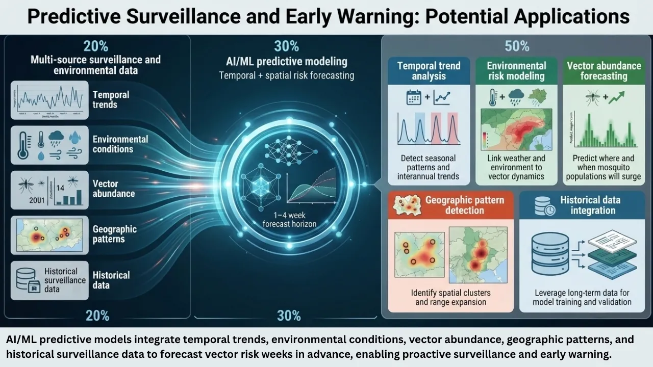
Machine-learning models can learn complex relationships among these variables. For example, they might detect that:
- A specific pattern of warm nights followed by moderate rainfall consistently precedes a rise in Culex abundance two to three weeks later.
- Certain combinations of temperature and vegetation indices predict increased Aedes activity in urban neighborhoods.
In one 2025 Bangladesh study (Rahman et al. 2025), an interpretable machine-learning model identified nonlinear relationships between dengue risk and environmental variables, including temperature and relative humidity. These thresholds should be interpreted as model-specific findings rather than universal biological cut-offs. This is the most natural “real data visual” of AI assisted predictive systems, of an actual reported relationship.
Predicted Dengue Risk Rises Sharply Past Reported Thresholds
Conceptual illustration of the non-linear relationship described by Rahman, Amrin & Shiddik (2025), whose tree-based ensemble model (Random Forest / XGBoost / LightGBM) flagged a sharp rise in predicted risk once mean temperature passed ~27°C and relative humidity passed ~82%.
Curve shapes are illustrative of the reported non-linear pattern, not digitised source data — the original study did not publish a plotted risk curve, only the identified thresholds and SHAP-based variable importance. Treat this as a conceptual aid, not a reproduction of the study’s figures.
Studies have demonstrated the potential of models integrating environmental and surveillance data to forecast vector dynamics or disease-related risk over future time periods, although performance varies by setting and forecast horizon (Mordecai et al., 2019; Ryan et al., 2019).
From prediction to early warning systems
A forecast on its own is not an early warning system.
To be useful, predictions must be:
- Timely: Generated early enough to inform decisions before risk materializes.
- Interpretable: Presented in a way that public-health managers can understand and act on (e.g., risk maps, alert levels).
- Integrated into workflows: Linked to standard operating procedures for surveillance and control.
Early warning systems often define thresholds or alert levels, such as:
- “Low,” “Moderate,” “High,” and “Very High” risk categories based on predicted vector abundance or infection probability.
- Trigger points that prompt specific actions: increase trap density, intensify larval source reduction, prepare adulticiding equipment, or issue public communications.
A critical principle for predictive surveillance is:
“Prediction should not be presented as certainty.“
All models carry uncertainty, arising from:
- Imperfect or incomplete input data
- Simplifications in how biological processes are represented
- Natural variability in vector and pathogen systems
- Unpredictable human behaviors and interventions
Good predictive systems therefore:
- Provide uncertainty estimates (e.g., confidence intervals, probability ranges) alongside point forecasts.
- Are continuously validated against new field data, with performance metrics tracked over time.
- Are updated or recalibrated as conditions change (e.g., new vector species, climate shifts, changes in surveillance methods).
Public-health users need to understand not just the forecast, but how confident the model is, and under what conditions it tends to over- or under-predict.
The need for local validation and contextual interpretation
Models trained on data from one region may not perform well in another without adaptation.
Reasons include:
- Different dominant vector species or complexes
- Distinct climate regimes and seasonal patterns
- Variations in urban structure, water management, and human behavior
- Differences in surveillance methods and data quality
Therefore, predictive models should be:
- Validated locally using historical and prospective data from the target area.
- Interpreted within the local epidemiological and ecological context by people who understand the system.
- Combined with expert judgment about upcoming events (festivals, construction projects, known problem sites) that models may not capture.
In practice, the most effective early warning systems are co-designed with local vector-control programs, epidemiologists, and decision-makers, ensuring that outputs match operational needs and constraints.
8. Digital Mosquito Surveillance Pathway: From Data to Public-Health Decisions
The ultimate goal of digital mosquito surveillance is not simply to generate more data, more sophisticated dashboards, or higher-performing models, but to improve the timeliness, quality, and usefulness of public-health decisions. None of the technology described above is worth much if it does not convert into better, helpful, timely, and targeted public health decisions.
All collected data undergoes a preprocessing stage before being fed into AI-driven systems. These systems detect and identify species, density, and population by leveraging GIS, spatial intelligence, and remote sensing technologies. The resulting insights support field workers and experts in optimizing trap placement, mapping risk zones, establishing rigorous monitoring areas, and enabling early warning systems along with health and disease alerts.
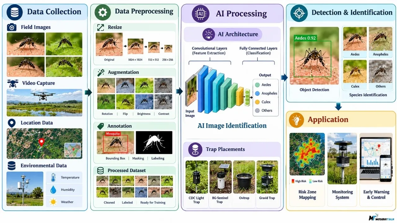
The intended pathway runs roughly as follows: field observations feed into digital data integration, which feeds AI-assisted analysis, which produces risk intelligence, which — critically — still has to be translated into an actual public-health decision. Without this final step, a surveillance program may produce a sophisticated dashboard without generating meaningful public-health action.
- Where does surveillance coverage need to expand?
- When should field investigation be intensified in a given district?
- Which neighbourhoods need closer monitoring because a predictive model has flagged rising risk?
- Where should limited larvicide, adulticide, or personnel resources be prioritised first?
- Is there a data gap serious enough that additional entomological or epidemiological investigation is needed before acting?
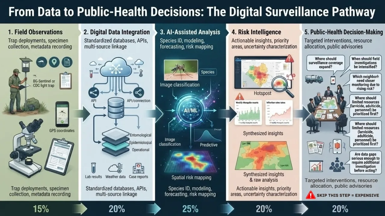
AI assisted Mosquito Control Surveillance Systems: The data-to-decision pathway
A useful way to think about modern surveillance is as a chain:
Field observations
Digital data integration
AI-assisted analysis
Risk intelligence
Public-health decision-making
Figure 1. Pathway from field data to public-health action. AI and digital tools augment, but do not replace, human expertise at each step.
1. Field observations
- Trap deployments and collections
- Specimen preservation and transport
- Metadata recording (location, date, trap type, environmental notes)
2. Digital data integration
- Entry into standardized databases or mobile apps
- Linking entomological records with lab results (species IDs, infection status)
- Integration with environmental, epidemiological, and operational datasets
3. AI-assisted analysis
- Automated or semi-automated species identification from images
- Modeling relationships between vectors, environment, and disease
- Generating spatial risk maps and temporal forecasts
4. Risk intelligence
- Synthesis of multiple data streams into clear, actionable insights
- Identification of hotspots, emerging trends, and priority areas
- Characterization of uncertainty and confidence levels
5. Public-health decision-making
- Adjusting surveillance intensity (where and when to trap more)
- Targeting interventions (larval control, adulticiding, source reduction)
- Issuing advisories to clinicians and the public
- Allocating resources (staff, equipment, budget) based on risk
At each step, digital tools can reduce friction, speed up processing, and reveal patterns that might otherwise remain hidden. But the chain is only as strong as its weakest link.
Turning surveillance information into operational questions
Well-designed surveillance systems help programs answer specific, operational questions, such as:
(i) Where is additional surveillance needed?
- Are there neighborhoods or habitats that are under-sampled but appear high risk based on environmental or historical data?
- Should new traps be installed in areas where models predict emerging suitability for key vectors?
(ii) When should field investigations be intensified?
- Do current forecasts suggest an upcoming surge in vector abundance or infection risk?
- Are there anomalies (e.g., unexpected species, unusually early peaks) that warrant rapid ground-truthing?
(iii) Which areas require closer monitoring?
- Are certain zones consistently associated with higher vector densities or pathogen detection?
- Do some areas show increasing trends over multiple seasons?
(iv) Where should resources be prioritized?
- Given limited staff and budget, which locations and activities will have the greatest impact on reducing risk?
- Should efforts focus on larval source reduction, adult mosquito control, public education, or a combination?
(v) Whether additional entomological or epidemiological data are needed?
- Do current data leave critical gaps (e.g., unknown species in a key area, unclear link between vectors and human cases)?
- Should targeted studies or enhanced surveillance be launched to resolve uncertainties?
These are not abstract questions. They drive weekly and seasonal operational plans in vector-control programs around the world.
Examples of decision pathways
While specific workflows vary by program, a typical decision pathway might look like this:
a) Weekly surveillance review:
- Entomology team reviews latest trap counts, species IDs, and infection results.
- AI-assisted tools highlight emerging hotspots and forecasted risk areas.
- GIS maps show spatial patterns and changes from previous weeks.
b) Risk assessment meeting:
- Vector-control managers, epidemiologists, and environmental health staff discuss findings.
- Models are used to explore “what-if” scenarios (e.g., if temperatures remain high, what happens to risk?).
- Uncertainty and limitations are explicitly considered.
c) Operational planning:
- Decisions are made on where to add or intensify traps next week.
- Which neighborhoods to prioritize for larval source reduction.
- Whether to schedule adulticiding in specific zones.
- What messages to communicate to the public and clinicians.
d) Feedback loop:
- Field teams report back on what they find in prioritized areas.
- New data are fed into databases and models.
- Plans are adjusted as conditions evolve.
In this loop, AI and digital tools are embedded, but human teams remain in control.
9. What AI Cannot Replace in Vector-Borne Disease Control
AI systems can identify statistical patterns in the data on which they are trained, but translating those patterns into biological explanations and context-specific public-health meaning requires domain expertise. Several things remain firmly in human hands regardless of how capable the models become.
AI should not be expected to replace:
- Biological interpretation
- AI can process patterns, but understanding their biological meaning requires biological expertise.
- Entomological field expertise
- Local knowledge of breeding sites, microclimates, and community behavior
- On-site judgment about trap placement, safety, and practicality
- Ability to notice subtle ecological cues that data alone miss
- Taxonomic knowledge
- Expert examination of closely related species and cryptic complexes
- Molecular confirmation when images or morphology are ambiguous
- Curation of reference collections and correction of misidentifications
- Understanding of local vector ecology
- Contextual interpretation of model outputs
- Integration of historical outbreak data and local transmission dynamics
- Adaptation to infrastructure, cultural, and environmental changes
- Field validation
- Ground-truthing of predicted hotspots and risk maps
- Investigation of anomalies and unexpected results
- Feedback to improve and recalibrate models
- Epidemiological interpretation
- Linking vector data to human cases, immunity, and healthcare access
- Accounting for changes in testing, reporting, and public behavior
- Judging the public-health significance of vector trends
- Public-health judgment
- Balancing risks, benefits, costs, and community concerns
- Ensuring equity in interventions and communications
- Making final decisions on alerts, interventions, and resource allocation
- Human oversight
- Expert review of AI outputs before operational use
- Authority to question, override, or refine model recommendations
- Responsibility for ethical, transparent, and accountable decision-making
AI can provide inputs — risk maps, forecasts, prioritization lists — but it cannot:
- Weigh ethical considerations
- Negotiate with stakeholders
- Decide what level of risk is “acceptable” or “urgent” in a given society
Those are inherently human judgments, rooted in values, experience, and on-site local context.
A useful rule of thumb for integrating AI into surveillance is: AI can process patterns, but understanding their biological and public-health meaning requires biological and epidemiological expertise.
10. The Data Quality Problem in AI-Based Vector Surveillance
More sophisticated algorithms and well trained AI models cannot fix a poor dataset. Better AI does not compensate for poor surveillance data and this is a hard truth at the center of any discussion about AI in mosquito surveillance.
Data quality and consistency strongly influence analysis
Model performance is fundamentally constrained by the quality, representativeness, and consistency of the data used for training, validation, and operational deployment.
Common data-quality issues include:
- Incomplete datasets: missing weeks, missing locations, missing metadata
- Geographical bias: over-representation of accessible or urban areas, under-sampling of rural or high-risk zones
- Poorly labeled images or records: misidentified species, incorrect coordinates, ambiguous trap types
- Limited seasonal coverage: data only during part of the transmission season, since most field studies run for a defined project period rather than continuously.
- Inconsistent sampling methods: changes in trap type, placement, or effort over time without documentation
- Underrepresentation of certain species or environments in training datasets (for AI models)
If these issues are not addressed, digital tools may:
- Learn the wrong patterns
- Produce confident but misleading outputs
- Reinforce existing biases (e.g., focusing only on well-sampled areas)
Public-health agencies increasingly recognize that data governance — standards for collection, storage, validation, and sharing — is as important as the analytical tools themselves (WHO, 2021; CDC, 2023).
WHO’s ethics guidance on artificial intelligence for health flags exactly this risk at a broader level: biased training data can produce systematically unequal outputs, and in health contexts this risk tends to disadvantage populations already carrying disproportionate disease burden (WHO, 2021; WHO, 2024).
11. Practical, Ethical, and Implementation Considerations
Introducing AI and digital tools into mosquito surveillance is not just a technical upgrade. It changes how data flow, who has access to what information, and how decisions are justified.
- Data privacy becomes relevant whenever location or household-level data is involved; mosquito surveillance increasingly overlaps with human-movement and residential data, which warrants the same governance scrutiny as any other health-adjacent dataset (WHO, 2021).
- Transparency matters as well. A predictive model that flags a district as high risk needs to be explainable enough for program staff to act on it with confidence rather than trust it blindly (WHO, 2024).
- False-positive and false-negative predictions can both have operational consequences. False positives may lead to unnecessary investigations or interventions, while false negatives may delay appropriate surveillance or response. Insecticide use should also be guided by integrated vector-management principles and resistance considerations.
- Human oversight needs to sit over every automated flag as a structural requirement rather than an afterthought.
- Cost and scalability differ enormously by setting: A solar-powered, IoT-enabled smart trap that performs well in a well-resourced pilot may face different maintenance, connectivity, cost, and workforce constraints when deployed at scale or in resource-limited settings (Liu et al., 2023; Muraro et al., 2026).
- Validation: Systems validated in one ecological and geographic context do not automatically transfer to another.
- And accessibility remains uneven — a global scoping review of smart mosquito-surveillance technologies published in 2026 found that formal cost-effectiveness evaluations comparing high-tech interventions against conventional manual surveillance were still largely absent from the literature, even as the underlying technology itself matured considerably (Muraro et al., 2026).
None of these argues against digital surveillance. It argues against assuming it works the same way, or delivers the same value, in every setting where it is tried.
12. The Future of Mosquito Surveillance: Human Expertise ✚ AI
The narrative around AI in public health often drifts toward opposite extremes.
1️⃣ One vision suggests that algorithms will soon automate surveillance end-to-end: traps that self-report, images that self-identify, models that self-correct, and dashboards that tell officials exactly what to do.
2️⃣ Another view treats AI as hype — a distraction from the unglamorous but essential work of field surveillance, lab identification, and community engagement. A more evidence-based view is to consider AI as one component of a broader, human-led surveillance system.
“The future of mosquito surveillance is unlikely to be defined by machines replacing experts. It is more likely to be defined by experts using intelligent tools to identify patterns that were previously difficult to see.”
The framing that keeps surfacing across this literature is not “AI vs. entomologists.” It is closer to AI + entomologists + epidemiologists + GIS specialists + public-health decision-makers, all working from a shared, faster stream of evidence.
From AI 🆚 Entomologists ➜ AI ✚ Entomologists ✚ Epidemiologists ✚ GIS ✚ Public Health
Framing the future as a competition — AI vs. entomologists — misses the point.
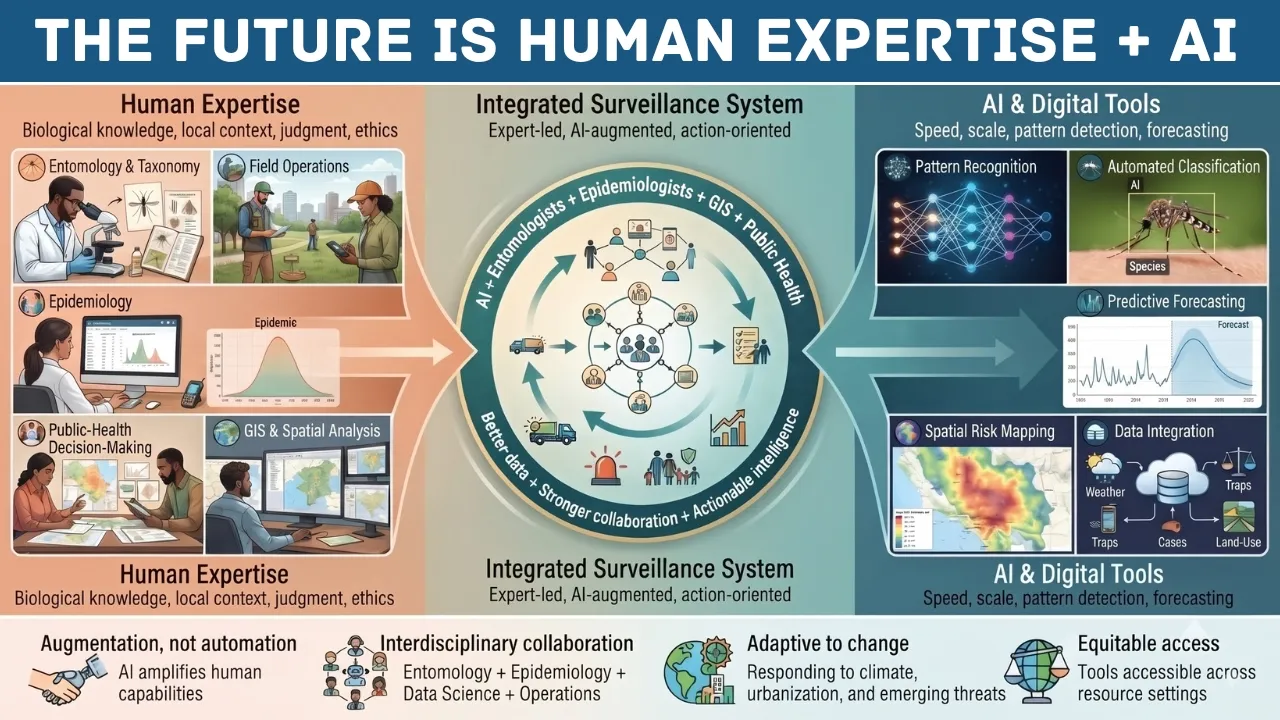
The real potential emerges when all these capabilities are combined:
- Entomologists who understand vector biology, taxonomy, and local ecology
- Epidemiologists who link vector data to human disease patterns and immunity
- GIS and data specialists who manage spatial data, models, and visualization
- Public-health managers who translate risk intelligence into operations, policy, and communication
In this view, AI is one component in a multidisciplinary surveillance system, not a standalone solution.
13. Conclusion
Mosquito surveillance’s future is unlikely to look like machines quietly replacing entomologists in a laboratory somewhere. It is more likely to look like entomologists, epidemiologists, and GIS analysts using considerably better tools to identify patterns that may be difficult to detect through conventional surveillance alone or may require substantial time and analytical effort to identify.
The future of mosquito surveillance will be shaped less by algorithms alone and more by how well public-health systems integrate these tools into expert-led, ethically grounded, and community-focused practice.
AI in mosquito surveillance is most appropriately viewed as an augmentation tool: it can extend analytical capacity while remaining dependent on high-quality data, field validation, and expert interpretation. The data quality it depends on, the field validation it still requires, and the public-health judgement it cannot replicate are not footnotes to that story. They are the story.
References
- CDC. 2023. West Nile Virus in the United States: Guidance for Surveillance and Control. Centers for Disease Control and Prevention, Atlanta, GA.
https://www.cdc.gov/west-nile-virus/php/surveillance-and-control-guidelines/index.html - CDC. 2024. ArboNET: National Arboviral Surveillance System. Centers for Disease Control and Prevention, Atlanta, GA.
https://www.cdc.gov/west-nile-virus/index.html - Kraemer, M. U. G., Reiner, R. C., Brady, O. J., Messina, J. P., Gilbert, M., Pigott, D. M., Yi, D., Johnson, K., Earl, L., Marczak, L. B., Shirude, S., Weaver, N. D., Bisanzio, D., Perkins, T. A., Lai, S., Lu, Q., Jones, A. E., Wunder, E. A., Siraj, A. S., … Hay, S. I. 2019. Past and future spread of the arbovirus vectors Aedes aegypti and Aedes albopictus. Nature Microbiology, 4(5), 854–863.
https://pmc.ncbi.nlm.nih.gov/articles/PMC6522366/ - Mordecai, E. A., Johnson, L. R., Rohr, J. R., et al. 2019. Optimal temperature for malaria transmission is dramatically lower than previously predicted. Ecology Letters, 22(1), 22–31.
https://www.researchgate.net/publication/232174855_Optimal_temperature_for_malaria_transmission_is_dramatically_lower_than_previously_predicted - Ryan, S. J., Carlson, C. J., Mordecai, E. A., & Johnson, L. R. 2019. Global expansion and redistribution of Aedes-borne virus transmission risk with climate change. PLOS Neglected Tropical Diseases, 13(3): e0007213.
https://pmc.ncbi.nlm.nih.gov/articles/PMC6438455/ - WHO. 2021. Global Vector Control Response 2017–2030: Mid-Term Review. World Health Organization, Geneva.
https://www.who.int/publications/i/item/9789241512978 - WHO. 2023. World Malaria Report 2023. World Health Organization, Geneva.
https://www.who.int/teams/global-malaria-programme/reports/world-malaria-report-2023 - Wilson, A. L., Boekee, C., & Lindsay, S. W. 2020. The importance of vector surveillance in the control of mosquito-borne diseases. Trends in Parasitology, 36(10), 845–857.
https://pmc.ncbi.nlm.nih.gov/articles/PMC6964823/ - Akter, M., Hossain, M.S., Ahmed, T.U., Andersson, K. (2021). Mosquito Classification Using Convolutional Neural Network with Data Augmentation. In: Vasant, P., Zelinka, I., Weber, GW. (eds) Intelligent Computing and Optimization. ICO 2020. Advances in Intelligent Systems and Computing, vol 1324. Springer, Cham.
https://doi.org/10.1007/978-3-030-68154-8_74 - Abbasi, E. (2025). Application of remote sensing and geospatial technologies in predicting vector-borne disease outbreaks. Royal Society Open Science, 12(10), 250536.
https://doi.org/10.1098/rsos.250536 - Bernhard Nocht Institute for Tropical Medicine (BNITM). (2025, October 15). Artificial intelligence identifies mosquito species by their wings. BNITM News.
https://www.bnitm.de/en/news/news/artificial-intelligence-identifies-mosquito-species-by-their-wings - Centers for Disease Control and Prevention (CDC). (2020). Continuation of mosquito surveillance and control during public health emergencies and natural disasters. MMWR, 69(28), 919–921. https://www.cdc.gov/mmwr/volumes/69/wr/mm6928a6.htm
- Centers for Disease Control and Prevention (CDC). (2025). Integrated mosquito management. https://www.cdc.gov/mosquitoes/php/toolkit/integrated-mosquito-management-1.html
- Couret, J., Moreira, D. C., Bernier, D., Loberti, A. M., Dotson, E. M., & Alvarez, M. (2020). Delimiting cryptic morphological variation among human malaria vector species using convolutional neural networks. PLOS Neglected Tropical Diseases, 14(3), e0008904.
https://journals.plos.org/plosntds/article?id=10.1371/journal.pntd.0008904 - Fuchida, M., Pathmakumar, T., Mohan, R. E., Tan, N., & Nakamura, A. (2017). Vision-based perception and classification of mosquitoes using support vector machine. Applied Sciences, 7(1), 51.
https://www.mdpi.com/2076-3417/7/1/51 - Gonzalez, C. R., Guzman, C., & Andreo, V. (2023). Using VHR satellite imagery, OBIA and landscape metrics to improve mosquito surveillance in urban areas. Ecological Informatics, 77, 102221.
https://www.sciencedirect.com/science/article/abs/pii/S1574954123002509?via%3Dihub - Goodwin, A., Padmanabhan, S., Hira, S., Glancey, M., Slinowsky, M., Immidisetti, R., Sivakumar, L., et al. (2021). Mosquito species identification using convolutional neural networks with a multitiered ensemble model for novel species detection. Scientific Reports, 11, 13656.
https://www.nature.com/articles/s41598-021-92891-9 - Høye, T. T., Ärje, J., Bjerge, K., Hansen, O. L. P., Iosifidis, A., Leese, F., Mann, H. M. R., Meissner, K., Melvad, C., & Raitoharju, J. (2021). Deep learning and computer vision will transform entomology. Proceedings of the National Academy of Sciences, 118(2), e2002545117.
https://www.pnas.org/doi/full/10.1073/pnas.2002545117 - Kalluri, S., Gilruth, P., Rogers, D., & Szczur, M. (2007). Surveillance of arthropod vector-borne infectious diseases using remote sensing techniques: A review. PLOS Pathogens, 3(10), e116.
https://journals.plos.org/plospathogens/article?id=10.1371/journal.ppat.0030116 - Liu, W.-L., Wang, Y., Chen, Y.-X., et al. (2023). An IoT-based smart mosquito trap system embedded with real-time mosquito image processing by neural networks for mosquito surveillance. Frontiers in Bioengineering and Biotechnology, 11, 1100968.
https://www.frontiersin.org/journals/bioengineering-and-biotechnology/articles/10.3389/fbioe.2023.1100968/full - Minakshi, M., Bharti, P., & Chellappan, S. (2018). Leveraging smart-phone cameras and image processing techniques to classify mosquito species. In Proceedings of the 15th EAI International Conference on Mobile and Ubiquitous Systems: Computing, Networking and Services (MobiQuitous ’18) (pp. 77–86). ACM.
https://dl.acm.org/doi/epdf/10.1145/3286978.3286998 - Muraro, M., Ligan, J. C. K., Bacco, L., Abate, L. D., Bwogi, E., Piaggio, D., Higley, C., Ovejero Paredes, K., Giovanetti, M., Merone, M., & Pecchia, L. (2026). How technologies are driving digital innovation in mosquito surveillance systems: A global scoping review over the past decade. BMJ Public Health, 4(2), e003145.
https://bmjpublichealth.bmj.com/content/4/2/e003145 - Nayak, P. P., Pai B., J., & Govindan, S. (2025). Leveraging geographic information system for dengue surveillance: A scoping review. Tropical Medicine and Health, 53, Article 62.
https://link.springer.com/article/10.1186/s41182-025-00783-9 - Rahman, M. S., Amrin, M., & Shiddik, M. A. B. (2025). Dengue early warning system and outbreak prediction tool in Bangladesh using interpretable tree-based machine learning model. Health Science Reports, 8(5), e70726.
https://onlinelibrary.wiley.com/doi/10.1002/hsr2.70726 - World Health Organization (WHO). (2012). Handbook for integrated vector management. WHO/HTM/NTD/VEM/2012.3.
https://www.who.int/publications/i/item/9789241502801 - World Health Organization (WHO). (2021). Ethics and governance of artificial intelligence for health: WHO guidance.
https://www.who.int/publications/i/item/9789240029200 - World Health Organization (WHO). (2024). Ethics and governance of artificial intelligence for health: Guidance on large multi-modal models.
https://www.who.int/publications/i/item/9789240084759 - Zhao, D.-Z., Wang, X.-K., Zhao, T., Chi, Q., Zheng, Y., & Wang, R. (2022). A Swin Transformer-based model for mosquito species identification. Scientific Reports, 12, 18664.
https://www.nature.com/articles/s41598-022-21017-6 - Dasari, S., Gopal, B., Nantale, M., Tugume, A., Kigozi, N., Arinaitwe, M., … & Chandran, A. 2024. A handheld tool for the rapid morphological identification of mosquito species (VectorCam) for community-based malaria vector surveillance: summative usability study. JMIR Human Factors, 11: e56605.
https://humanfactors.jmir.org/2024/1/e56605/ - Gonzalez, F., Muraro, D., & Silva, R. 2023. Deep learning and drone-based remote sensing for mapping Anopheles breeding habitats in West African agricultural landscapes. Remote Sensing of Environment, 295: 113642.
- Lakyiere, C., Adjei, E., Amankwa, E. O., Agyemang, M., & Oduro, I. 2025. Trends and advances in image-based mosquito identification and classification using machine learning models: a systematic review. Computers in Biology and Medicine, 193: 110373.
https://www.sciencedirect.com/science/article/abs/pii/S0010482525007243 - Liu, X., Chen, Y., Wang, H., & Zhang, J. 2023. An IoT-based smart mosquito trap system embedded with real-time mosquito image processing by neural networks for mosquito surveillance. Frontiers in Bioengineering and Biotechnology, 11: 1100968.
https://pmc.ncbi.nlm.nih.gov/articles/PMC9895108/ - NDTV Health. 2026. Kerala’s new dengue early warning system uses AI to predict trends. 28 September 2026.
https://www.ndtv.com/health/keralas-new-dengue-early-warning-system-uses-ai-to-predict-trends-12108439 - Elets eHealth. 2025. Andhra Pradesh unveils AI-powered SMoSS to tackle mosquito-borne diseases. 7 July 2025.
https://ehealth.eletsonline.com/2025/07/andhra-pradesh-unveils-ai-powered-smoss-to-tackle-mosquito-borne-diseases/
Editorial Team & Contributors

Atefeh Khazeni, PhD, Medical Entomologist | Vector-Borne Diseases | Public Health
Atefeh Khazeni, PhD, is a medical entomologist and public health researcher with expertise in vector-borne diseases, vector surveillance, and mosquito biology. Her research and professional interests include the application of artificial intelligence and digital technologies to vector surveillance and public health. She has extensive experience in academic research, teaching, disease control programs, and scientific collaboration in the field of medical entomology.

Raashid Ansari, Founder, Content Researcher & Author - MosquiTalk
Not an entomologist — just a genuinely curious writer who started researching mosquitoes and couldn't stop. What began as casual reading about repellents and bite prevention gradually turned into a deep ongoing dive into vector biology, disease epidemiology, animal health impacts, and the real science behind mosquito control. Everything published here is carefully edited, and written with one purpose: giving readers accurate, accessible information they can actually trust and use to protect themselves, their families, and their pets, birds and cattle.
Active across social platforms, regularly publishes, and genuinely invested in spreading mosquito awareness where it matters most. Because informed readers make better decisions — and better decisions save lives.